Ennerdale Travel Guide

Ennerdale — the Lake District's westernmost, wildest secret valley. No road runs alongside the lake, no pleasure boat cuts through its emerald waters. This is England's earliest rewilding experiment, where nature is reshaping the landscape in its rawest form. In 1826, shepherd John Atkinson climbed Pillar Rock from here, igniting the flame of Lake District mountaineering. Today you can still trace a 600-year-old smithy settlement along the Smithy Beck path, or stand atop Bowness Knott and gaze simultaneously at the Irish Sea and the Lakeland peaks. This 2-day, 1-night classic tour includes lakeside hiking, rewilded valley exploration, ancient ruin hunting, and a pilgrimage to the birthplace of climbing.

3.9
Kilometres Lake Length
1826
First Ascent of Pillar Rock
600
Years of Smithy Beck Settlement
0
Lakeside Roads
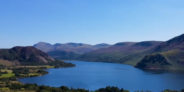
Panorama of Ennerdale Water and the rewilded valley, with Pillar Rock standing on the distant ridge
Ennerdale Water
The Lake District's westernmost and least-known lake, its emerald waters encircled by the three great peaks of Pillar, Steeple and Great Gable. No road touches its shores — only forest paths and rugged rocks remain, a wilderness forgotten by time.

Ennerdale 2-Day, 1-Night Classic Tour

Kayak England's westernmost wild lake, hike the rewilded valley tracing ancient settlements, and climb Pillar Rock — the birthplace of Lake District mountaineering.

Duration
2 Days / 1 Night
Main Destinations
Ennerdale Water, Smithy Beck Ancient Track, Pillar Rock, Bowness Knott, Ennerdale Bridge, Shepherd's Arms
Suitable For
Climbers, Hikers, Nature Observers, Eco-travellers, Photography Enthusiasts
Budget per Person
£25 - £80
01
Lake & Ancient Track
Ennerdale Water Loop · Smithy Beck Ancient Track · Angler's Crag · Ennerdale Bridge · Shepherd's Arms
Highlights

Start from the free Bleach Green car park and embark on the Round the Lake walk (6.5 miles / 10.5 km, about 4 hours). The path winds along the shoreline: the western side opens onto broad lake views across to Side Wood's ancient woodland, while the eastern side requires a scramble over a 200-metre rocky ledge beneath Angler's Crag — hands-on, hugging the cliff face, the most thrilling and memorable section of the entire route. Standing on the ledge, you look down on the emerald stillness of the lake, with Pillar Rock rising like a giant pillar into the sky beyond. Descending to the eastern shore, you cross pine forests and fern brakes to picnic on the grass at the site of the old Angler's Hotel — once a Victorian anglers' retreat, now only crumbling walls and wildflowers remain. In the afternoon, turn onto the Smithy Beck Path — a 2-mile (3.2 km) circular trail linking the ruins of a 600-year-old iron-smelting settlement. The double-layer stone walls of the longhouse are still clearly visible; archaeologists say this unique construction proves year-round habitation, not just seasonal grazing. When the ferns die back in winter, the ancient walls emerge like dragons' spines across the hillside — the best season for photography. Return in the evening to Ennerdale Bridge village, order a pint of local Ennerdale Brewery bitter at the Shepherd's Arms, enjoy Cumberland sausage platter by the fire, and listen to tales from Coast to Coast walkers in the bar.

Attractions
Ennerdale Water
The Lake District's westernmost and least-known lake, approximately 3.9 km long, 45 metres deep, at an altitude of 113 metres. No road runs alongside the lake — the only ways to travel are on foot, by bike, or by canoe. The water is crystal clear, home to brown trout, sea trout, and the rare Arctic charr. Swimming and stand-up paddleboarding are prohibited, but canoes and kayaks may launch freely (groups of 5+ require a free permit from United Utilities).
Smithy Beck Ancient Track & Settlement Ruins
One of nine Scheduled Ancient Monuments in the Ennerdale Valley, a medieval ironworking settlement over 600 years old. The double-layer stone walls of the longhouse are most clearly visible when winter ferns die back, proving year-round occupation for smelting, grazing, and farming. The trail is 2 miles (3.2 km) long, taking about 1 hour, suitable for families though uneven in parts (not buggy-friendly). Free downloadable guide map available from the Wild Ennerdale website.
Ennerdale Bridge & Shepherd's Arms
A tiny village on the banks of the River Ehen, the gateway to the Ennerdale Valley and a compulsory stop on the Coast to Coast route. The Shepherd's Arms began as a farmer's house selling home-brewed ale to passers-by and is now an award-winning Lakeland cottage pub. Specialities include Cumberland lamb, local rib-eye steak, and Cumberland sausages, served with Cumbrian Legendary Ales, Ennerdale Brewery and other local craft beers. Has 8 guest rooms and is a classic resting place for long-distance walkers.
Practical Info
Accommodation
  • Shepherd's Arms Hotel (award-winning pub + accommodation)
  • YHA Black Sail (deepest valley mountain hut, opened 1933)
  • Low Gillerthwaite Field Centre (group bunkhouse)
  • B&B near Gather Ennerdale community centre
Food Recommendations
  • Shepherd's Arms Cumberland sausage & lamb pie
  • Fox and Hounds traditional English pub fare
  • Gather Ennerdale community café
  • Self-catered picnic (no shops in the valley)
Travel Tips
  • No mobile signal in the valley; download offline maps
  • Angler's Crag ledge is extremely slippery when wet; do not risk it
  • Free car park at Bleach Green; paid parking at Bowness Knott
  • Free-roaming Galloway cattle in the valley; keep your distance
02
Crag & Ridge
Pillar Rock · Bowness Knott Summit · Liza Riverside Trail · Rewilded Forest · Ennerdale Show
Highlights

Set off early from the Bowness Knott car park, cycling or hiking deep into the valley along the forest road. Bowness Knott stands at just 332 metres, yet offers the finest panorama of Ennerdale — a 20-minute climb rewards you with the sight of three great peaks lined up before you: Pillar (892m), Steeple (819m), and Great Gable (899m), with the lake set like a jade gem between forest and meadow, and the distant outline of the Irish Sea and the Isle of Man to the west. In the morning, follow the Liza riverside trail eastwards into the heart of the rewilding zone. The river leaps between gravel bars and deep pools; tall Scots pines and birches are replacing monoculture plantations — the result of over 20 years of rewilding by the Wild Ennerdale Partnership (National Trust + Forestry Commission + United Utilities, founded 2003). Track wildlife signs: red deer hoof prints, otter slides, and the silhouette of white-tailed eagles overhead. In the afternoon, take the Pilgrim's Path to Pillar Rock — ascend from the valley floor along the ridge to the start of the Slab and Notch route (about 2 hours). Look up at this colossal rock pillar perched on the mountainside. In 1826, shepherd John Atkinson completed the first recorded ascent here, launching the history of British rock climbing. Even without climbing, standing at the foot of the pillar and feeling its overwhelming mass is a breathtaking experience. If you visit on the last Wednesday of August, head to Kirkland Leaps for the 118th Ennerdale Show — one of Britain's oldest agricultural shows, featuring sheepdog trials, Cumberland wrestling, and stick judging, unmissable traditions of the Lake District countryside.

Attractions
Bowness Knott Viewpoint
A low hill at 332 metres, reached in just 20 minutes from the car park, yet offering the most spectacular panoramic view of Ennerdale: the emerald lake at your feet, the three peaks of Pillar, Steeple, and Great Gable standing shoulder to shoulder in the distance, and on clear days the Irish Sea and Isle of Man visible on the western horizon. A picnic area and cycle trail start at the base, making it ideal for families. Note: Long Crag is closed to climbing from 1 March to 30 June due to peregrine falcon nesting.
Pillar Rock & Slab and Notch Route
A massive independent rock pillar on the flank of Pillar, the eighth-highest fell in the Lake District, and the birthplace of British rock climbing. Shepherd John Atkinson made the first recorded ascent via the Old West route in 1826 (grade Moderate). Classic routes such as Slab and Notch (1863) and North Climb (1891, Severe) followed. A bottle on the summit holds the names of generations of climbers. Non-climbers can walk 2 hours from the valley floor along the forest road to stand at the foot of the pillar — equally awe-inspiring.
Wild Ennerdale Rewilding Zone (Liza River)
One of England's earliest rewilding projects, launched in 2003 by the National Trust, Forestry Commission, and United Utilities. The core zone unfolds along the River Liza, which is being allowed to return to its natural meandering course. Plantation forestry is gradually being replaced by mixed native oak, birch, and pine woodland. Galloway cattle and a small number of wild boar roam freely year-round to manage vegetation. An excellent location for spotting red deer, otters, white-tailed eagles, and rare freshwater pearl mussels. Also home to five permanent orienteering courses.
Practical Info
Transport
  • No direct public transport; nearest railway station Whitehaven (8 miles)
  • Driving: A5086 to Ennerdale Bridge, then minor road
  • Bowness Knott paid car park (managed by Forestry England)
  • Bleach Green free car park (lake loop start point)
Tickets & Fees
  • Ennerdale Water & Valley: Completely free
  • Bowness Knott parking: £5-£8/day
  • Bleach Green parking: Free
  • Canoe/Kayak: Free (permit needed for groups of 5+)
  • YHA Black Sail bunk: approx £25/night
Travel Tips
  • Bring a paper map or GPS; no mobile signal in the valley
  • Tick prevention: wear long trousers tucked into socks; check thoroughly afterwards
  • The valley is a wind funnel (Windy Gap); bring a windproof jacket even on sunny days
  • Ennerdale Show: last Wednesday of August, Kirkland Leaps

Must-Eat in Ennerdale

Shepherd's Arms Traditional Pub

The heart of Ennerdale Bridge village, an award-winning cottage pub evolved from a farmer's house. Specialising in local Lake District ingredients: Cumberland sausages, Lakeland lamb pie, rib-eye steak — all freshly cooked. The drinks list draws almost entirely from Cumbrian breweries (Cumbrian Legendary Ales, Ennerdale, Hawkshead, Keswick). A classic stop for Coast to Coast walkers. Budget £12-£25 per person.

Gather Ennerdale Community Café

A community-run café in the centre of Ennerdale Bridge, serving hot drinks, homemade cakes, sandwiches, and soup — the last refuelling stop before entering the valley. All profits go towards maintaining valley paths and public facilities. Warm and rustic atmosphere. Open until dusk in summer, weekends only in winter. Budget £5-£12 per person.

Fox and Hounds Village Pub

Another traditional pub beside the church in Ennerdale Bridge, opposite the Shepherd's Arms across the river. Famous for fireside dinners and local malt ales. Sunday roast is the signature dish; the light menu includes fish & chips, shepherd's pie, and vegetable soup. Dog-friendly (until 18:00), with a small beer garden. Budget £10-£20 per person.

Ennerdale Bridge Village Shop

The only general store in the valley, selling bread, cheese, ham, fruit, and drinks — the essential stop for assembling a picnic basket. Also stocks local honey, jams, and Lake District handmade chocolates, perfect as souvenirs. Opening hours limited (usually 10:00-17:00), so shop in the morning. The friendly staff are happy to give walking advice.

Ennerdale Travel Tips
Best Time to Visit
  • May-Sep: Trails fully open, long daylight, wildflowers in bloom
  • Last Wednesday of August: Ennerdale Show
  • Winter: Ancient settlement stone walls most clearly visible
  • Mar-Jun: Long Crag closed to climbing (peregrine nesting)
Must-Try Foods
  • Cumberland Sausage (Shepherd's Arms)
  • Ennerdale Brewery Local Bitter
  • Lakeland Lamb Pie
  • Lake District Artisan Cheese Board
  • Local Honey & Jam
Budget Reference
  • Parking: £0 (Bleach Green free) - £8/day
  • Accommodation: £25 (YHA) - £90 (Shepherd's Arms)/night
  • Meals: £10-£25/day
  • Kayak Hire: approx £15-£25/half day
  • Total: £25-£80
FAQ
  • Can I swim in the lake? → Swimming is prohibited in Ennerdale Water; canoeing/kayaking allowed
  • Is there mobile reception? → Almost no signal in the valley; download offline maps
  • Can I bring my dog? → Yes, but must be kept on a lead at all times (cattle and sheep present)
  • How do I get there? → By car recommended; no direct public transport

Explore More of the Lake District